


Parking Analytics®
DCX Innovations PARKINGANALYTICS combines highly accurate real data acquisition with processing of mass data in the real time.
A city parking department needs valid data of real-time information to make informed decisions
Having appropriate data, a city can tackle multiple modern challenges related to:
Precise occupancy rates of parking zones
User-specific parking space usage data
Prediction of future utilization rates


That Data can be gathered without the need to install a single fixed sensor simply by using our Mobile MultiSensor™ technology.
Using digital tools for scanning


Using the Mobile MultiSensor™ system CITYSCANNER® for the acquisition of real data in selected time intervals.

Mobile MultiSensor™ technology
The combination of highly accurate real data acquisition and fast processing of mass data in the onboard processing unit and anonymization package.
Data safety first
On the edge advantage of Mobile MultiSensor™ ensures data safety:

All the data captured is anonymized in real-time on the edge (inside the car)
Having a computing unit on board enables CITYSCANNER® vehicles to execute the full anonymization and the final preparation of the data according to the defined interface inside the car.
The data collected is immediately anonymized and does not contain any identifying information about the people or other vehicles in the file. This is done on the edge at the hardware level to ensure that the stored data is completely and irrevocably anonymized.
Statistics based on license plates are executed by using asymmetric cryptography to be compliant with the strongest data protection regulations.

FINAL dataset: what is saved anywhere in the systems database.
in Corelation with existing data

Now you will have a technology available that enables precise statistics for large areas and multiple days.
Mapping

Using our Mobile MultiSensor™ - DCX Innovations in process of
determination of the current parking space
Geometry of polygons per each parking zone (in *.json format)

Parking spaces are combined with Parking polygons which are classified by up to 20 attributes (Reserved for people with disabilities, EV-only parking, residents only, etc.)
Results are presented and can be displayed in web application and saved in GEO *.json format.
Number of parking spaces
Management form
Attributes
Time Regulations

Add attributes of Parking space
Data on user behavior

User specific information
parking duration analytics
Parking time according to time occupancy, e.g. 1-3h, 3-10h, 10-24h,> 24h
The ratio of commuters to short parking duration
Ratio of residents’ vehicles to visitors
Utilization rates


Overview of parking space utilization and exact change rates before and after initializing payment requirements.
Data is captured on different days (weekdays and weekends) at up to five different day and night times.
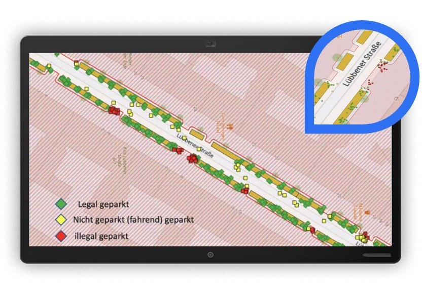
Parking Violations

Scan even very close parked cars and record violations thanks to unprecedented precision
Even very close parked cars are scanned for parking violations with quantification and precise data and photo-documentation
Analysis of dangerous parking violations based on the exact location of the vehicle parked on
Loading areas
Fire zones
Places for people with disabilities
Other restricted areas
Data can be used for statistical purposes and real-time enforcement


Mobile MultiSensor™ does not require hardware installation, power supply, connectivity, and maintenance, for every single area that you want to monitor.
Mobile MultiSensor™ is easily scalable just add vehicles with the system or increase the scanned zone.
Bespoke data gathering and analytics made to your custom needs
DCX Innovations also execute the data gathering project for you using our Mobile MultiSensor™
Define your challenge/area of interest and our expert team will provide a solution.
